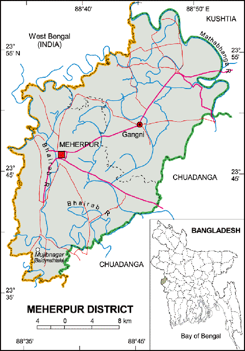
Meherpur District (Khulna division) with an area 716.08 sq km, is bounded by kushtia district and West Bengal of India on the north, chuadanga district and West Bengal on the south, Chuadanga and kushtia districts on the east, West Bengal on the west. Main rivers are Bhairab, Mathabhaga and Kazli; Main depressions: Dharlar Beel, Chandbeel, Kolar Beel, Patapukur Beel, Gopalpur Beel, Bamandi Beel, Salika Beel, Terogharia Beel, Elangi Beel. Annual average temperature: highest 37.1°C and lowest 11.2°C; annual rainfall 1467 mm.
Meherpur (Town) consists of 9 wards and 72 mahallas. It has an area of 13.62 sq km. The population of the town is 35771; male 52.33%, female 47.67%. The density of population is 2626 per sq km. Literacy rate among the town people is 49.4%. The town was established in the beginning of the 16th century. Meherpur municipality was established in 1960.
Administration Before the partition (1947) Meherpur was a part of the Nadia district of India. The Meherpur subdivision was turned into a district in 1984. It consists of 1 municipality, 9 wards and 72 mahallas, 2 upazilas, 18 union parishads, 277 villages, 190 mouzas. The upazilas are meherpur sadar, gangni and mujibnagar.
This is a Non-Profit and Personal (Un-Official) website for Mujibnagar. Mujibnagar Information Portal (MUJIBNAGAR.COM). We always want to give all information about Mujibnagar, Mujibnagar Government, Mujibnagar History, Mujibnagar Complex, Mujibnagar Memorial Monument, Mujibnager Picnic Sport and more Information… Read More